
Eben am Achensee topographic map
Interactive map
Click on the map to display elevation.
About this map
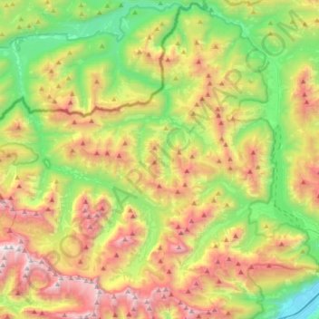
Name: Eben am Achensee topographic map, elevation, terrain.
Location: Eben am Achensee, Bezirk Schwaz, Autriche (47.38074 11.44933 47.56787 11.78199)
Average elevation: 1,401 m
Minimum elevation: 523 m
Maximum elevation: 2,703 m
Other topographic maps
Click on a map to view its topography, its elevation and its terrain.
Pertisau
Autriche > Bezirk Schwaz > Eben am Achensee
Pertisau, Eben am Achensee, Bezirk Schwaz, Tyrol, 6213, Autriche
Average elevation: 1,141 m
Maurach
Autriche > Bezirk Schwaz > Eben am Achensee
Maurach, Eben am Achensee, Bezirk Schwaz, 6212, Autriche
Average elevation: 1,197 m