Geolocate

Bridgeport topographic map

Click on the map to display elevation.

About this map

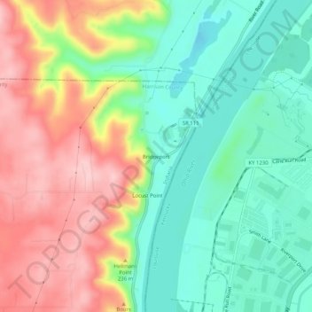
Name: Bridgeport topographic map, elevation, terrain.

Location: Bridgeport, Harrison County, Indiana, United States (38.15618 -85.92635 38.19618 -85.88635)

Average elevation: 185 m

Minimum elevation: 107 m

Maximum elevation: 293 m

Other topographic maps

Click on a map to view its topography, its elevation and its terrain.

Lanesville

United States > Indiana > Harrison County

Average elevation: 239 m

New Amsterdam

United States > Indiana > Harrison County

Average elevation: 151 m

New Middletown

United States > Indiana > Harrison County

Average elevation: 215 m

Crandall

United States > Indiana > Harrison County

Average elevation: 217 m

Laconia

United States > Indiana > Harrison County

Average elevation: 201 m

Gear up for your next adventure:

🧴Sunscreen SPF - Broad-spectrum sunscreen for outdoor activities
🛌Insulated Sleeping Pad - Critical thermal barrier between you and the cold ground
Lightweight Backpacking Tent - Compact tent for efficient hiking trips
🔨Vehicle Emergency Tool - Safety tool for remote road trips to trailheads
Bushcraft Tarp - Versatile emergency shelter or gear protection

As an Amazon Associate, this site earns from qualifying purchases at no extra cost to you.