
Make a donation
Gear up for your next adventure:
As an Amazon Associate, this site earns from qualifying purchases at no extra cost to you.
Laas - Lasa topographic map
Click on the map to display elevation.
Make a donation
Gear up for your next adventure:
As an Amazon Associate, this site earns from qualifying purchases at no extra cost to you.
About this map
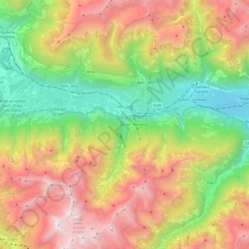
Name: Laas - Lasa topographic map, elevation, terrain.
Average elevation: 1,905 m
Minimum elevation: 655 m
Maximum elevation: 3,521 m
Make a donation
Gear up for your next adventure:
As an Amazon Associate, this site earns from qualifying purchases at no extra cost to you.
Other topographic maps
Click on a map to view its topography, its elevation and its terrain.
Sohlern - Solerno
Italië > Trentino-Zuid-Tirol > Bolzano - Bozen > Vintl - Vandoies > Niedervintl - Vandoies di Sotto
Average elevation: 1,145 m
Lengmoos - Longomoso
Italië > Trentino-Zuid-Tirol > Bolzano - Bozen > Ritten - Renon > Klobenstein - Collalbo
Average elevation: 1,049 m
Eben - Pramarino
Italië > Trentino-Zuid-Tirol > Bolzano - Bozen > Anterivo - Altrei > Altrei - Anterivo
Average elevation: 1,187 m
Reschenpass - Passo Resia
Italië > Trentino-Zuid-Tirol > Bolzano - Bozen > Graun - Curon Venosta > Froi - Froia
De Reschenpas (Duits: Reschenpass, Italiaans: Passo di Resia) is een bergpas in de Rätische Alpen op de grens tussen Oostenrijk en Italië. De pas verbindt de Oostenrijkse deelstaat Tirol met de regio Vinschgau in Zuid-Tirol. De bergpas vormt tevens de scheiding tussen de Ötztaler Alpen en de Sesvennagroep.…
Average elevation: 1,693 m
Make a donation
Gear up for your next adventure:
As an Amazon Associate, this site earns from qualifying purchases at no extra cost to you.
Secёda - Monte Seceda
Italië > Trentino-Zuid-Tirol > Bolzano - Bozen > Santa Cristina Gherdëina - St. Christina in Gröden - Santa Cristina Valgardena
Average elevation: 2,106 m
Make a donation
Gear up for your next adventure:
As an Amazon Associate, this site earns from qualifying purchases at no extra cost to you.
Gomagoi
Italië > Trentino-Zuid-Tirol > Bolzano - Bozen > Stilfs - Stelvio > Stilfserbrücke - Ponte Stelvio
Average elevation: 1,677 m
Oberinn - Auna di Sopra
Italië > Trentino-Zuid-Tirol > Bolzano - Bozen > Ritten - Renon
Average elevation: 1,315 m
St. Magdalena - Santa Maddalena in Casies
Italië > Trentino-Zuid-Tirol > Bolzano - Bozen > Gsies - Valle di Casies
Average elevation: 1,772 m
Make a donation
Gear up for your next adventure:
As an Amazon Associate, this site earns from qualifying purchases at no extra cost to you.
Seis am Schlern - Siusi allo Sciliar
Italië > Trentino-Zuid-Tirol > Bolzano - Bozen > Kastelruth - Castelrotto
Average elevation: 1,211 m
Secёda - Monte Seceda
Italië > Trentino-Zuid-Tirol > Bolzano - Bozen > Santa Cristina Gherdëina - St. Christina in Gröden - Santa Cristina Valgardena
Average elevation: 2,106 m
Großhorn - Corno Grande
Italië > Trentino-Zuid-Tirol > Bolzano - Bozen > Graun - Curon Venosta
Average elevation: 2,295 m
Make a donation
Gear up for your next adventure:
As an Amazon Associate, this site earns from qualifying purchases at no extra cost to you.
Sulden - Solda
Italië > Trentino-Zuid-Tirol > Bolzano - Bozen > Stilfs - Stelvio
Average elevation: 2,232 m
St. Magdalena - Santa Maddalena in Casies
Italië > Trentino-Zuid-Tirol > Bolzano - Bozen > Gsies - Valle di Casies
Average elevation: 1,772 m
Mitterstieler See - Lago di mezzo
Italië > Trentino-Zuid-Tirol > Bolzano - Bozen > Ritten - Renon > Eschenbach
Average elevation: 1,022 m
Timmelsjoch - Passo Rombo
Italië > Trentino-Zuid-Tirol > Bolzano - Bozen > Moos in Passeier - Moso in Passiria
Average elevation: 2,483 m
Make a donation
Gear up for your next adventure:
As an Amazon Associate, this site earns from qualifying purchases at no extra cost to you.
Prad am Stilfser Joch - Prato allo Stelvio
Italië > Trentino-Zuid-Tirol > Bolzano - Bozen > Prad am Stilfserjoch - Prato allo Stelvio
Average elevation: 1,078 m
San Ćiascian - St. Kassian - San Cassiano
Italië > Trentino-Zuid-Tirol > Bolzano - Bozen
Average elevation: 1,761 m
Aufkirchen - Santa Maria
Italië > Trentino-Zuid-Tirol > Bolzano - Bozen > Toblach - Dobbiaco
Average elevation: 1,429 m
Make a donation
Gear up for your next adventure:
As an Amazon Associate, this site earns from qualifying purchases at no extra cost to you.
Latzfons - Lazfons
Italië > Trentino-Zuid-Tirol > Bolzano - Bozen > Klausen - Chiusa
Average elevation: 1,231 m
Oberbozen - Soprabolzano
Italië > Trentino-Zuid-Tirol > Bolzano - Bozen > Ritten - Renon
Average elevation: 1,123 m
Wolfeskofel - Monte Lupo
Italië > Trentino-Zuid-Tirol > Bolzano - Bozen > Ahrntal - Valle Aurina
Average elevation: 1,662 m
St. Anton - Sant'Antonio
Italië > Trentino-Zuid-Tirol > Bolzano - Bozen > St. Nikolaus - San Nicolò
Average elevation: 745 m
Make a donation
Gear up for your next adventure:
As an Amazon Associate, this site earns from qualifying purchases at no extra cost to you.
La Vila
Italië > Trentino-Zuid-Tirol > Bolzano - Bozen > Sëlva - Wolkenstein - Selva di Val Gardena
Average elevation: 1,861 m
Luns - Lunes
Italië > Trentino-Zuid-Tirol > Bolzano - Bozen > Bruneck - Brunico
Average elevation: 1,061 m
St. Anton - Sant'Antonio
Italië > Trentino-Zuid-Tirol > Bolzano - Bozen > St. Nikolaus - San Nicolò
Average elevation: 745 m
Butzenspitze - Cima Pozzo
Italië > Trentino-Zuid-Tirol > Bolzano - Bozen > Stilfs - Stelvio
Average elevation: 2,940 m
Make a donation
Gear up for your next adventure:
As an Amazon Associate, this site earns from qualifying purchases at no extra cost to you.
Madritschspitze - Cima Madriccio
Italië > Trentino-Zuid-Tirol > Bolzano - Bozen > Stilfs - Stelvio
Average elevation: 2,970 m
Vigiljoch - Monte San Vigilio
Italië > Trentino-Zuid-Tirol > Bolzano - Bozen > Lana
Average elevation: 1,650 m
Hirschegg - Punta del Cervo
Italië > Trentino-Zuid-Tirol > Bolzano - Bozen > Sarntal - Sarentino
Average elevation: 2,158 m
Luttach - Lutago
Italië > Trentino-Zuid-Tirol > Bolzano - Bozen > Ahrntal - Valle Aurina
Average elevation: 1,372 m
Make a donation
Gear up for your next adventure:
As an Amazon Associate, this site earns from qualifying purchases at no extra cost to you.
Pater
Italië > Trentino-Zuid-Tirol > Bolzano - Bozen > Welschnofen - Nova Levante
Average elevation: 2,153 m
Villa Nöia
Italië > Trentino-Zuid-Tirol > Bolzano - Bozen > La Ila - Stern - La Villa
Average elevation: 1,632 m
Oberplars - Plars di Sopra
Italië > Trentino-Zuid-Tirol > Bolzano - Bozen > Vellau - Velloi
Average elevation: 786 m
Make a donation
Gear up for your next adventure:
As an Amazon Associate, this site earns from qualifying purchases at no extra cost to you.
Huiben
Italië > Trentino-Zuid-Tirol > Bolzano - Bozen > Gsies - Valle di Casies > St. Magdalena - Santa Maddalena in Casies
Average elevation: 1,816 m
Antholz Obertal - Anterselva di Sopra
Italië > Trentino-Zuid-Tirol > Bolzano - Bozen > Rasen-Antholz - Rasun-Anterselva
Average elevation: 1,822 m
Bichl - Colle
Italië > Trentino-Zuid-Tirol > Bolzano - Bozen > Jenesien - San Genesio Atesino
Average elevation: 976 m
Make a donation
Gear up for your next adventure:
As an Amazon Associate, this site earns from qualifying purchases at no extra cost to you.
Maiern - Masseria
Italië > Trentino-Zuid-Tirol > Bolzano - Bozen > Ratschings - Racines
Average elevation: 1,778 m
Katharinaberg - Monte Santa Caterina
Italië > Trentino-Zuid-Tirol > Bolzano - Bozen > Schnals - Senales
Average elevation: 1,611 m
Windegg
Italië > Trentino-Zuid-Tirol > Bolzano - Bozen > St. Leonhard in Passeier - San Leonardo in Passiria
Average elevation: 1,056 m
Bircher Höfe
Italië > Trentino-Zuid-Tirol > Bolzano - Bozen > Taufers - Tures
Average elevation: 1,284 m
Make a donation
Gear up for your next adventure:
As an Amazon Associate, this site earns from qualifying purchases at no extra cost to you.
Gherdëina - Grödnertal - Val Gardena
Italië > Trentino-Zuid-Tirol > Bolzano - Bozen > Urtijëi - St. Ulrich in Gröden - Ortisei
Average elevation: 1,588 m
Make a donation
Gear up for your next adventure:
As an Amazon Associate, this site earns from qualifying purchases at no extra cost to you.
Tagusens - Tagusa
Italië > Trentino-Zuid-Tirol > Bolzano - Bozen > Kastelruth - Castelrotto
Average elevation: 917 m
Mitterolang - Valdaora di Mezzo
Italië > Trentino-Zuid-Tirol > Bolzano - Bozen
Average elevation: 1,154 m
Plan da Tieja
Italië > Trentino-Zuid-Tirol > Bolzano - Bozen > Sëlva - Wolkenstein - Selva di Val Gardena
Average elevation: 1,747 m
Make a donation
Gear up for your next adventure:
As an Amazon Associate, this site earns from qualifying purchases at no extra cost to you.
Entiklar - Niclara
Italië > Trentino-Zuid-Tirol > Bolzano - Bozen > Kurtatsch an der Weinstraße - Cortaccia sulla Strada del Vino
Average elevation: 512 m
Al Plan de Mareo - St. Vigil in Enneberg - San Vigilio di Marebbe
Italië > Trentino-Zuid-Tirol > Bolzano - Bozen > Marèo - Enneberg - Marebbe
Al Plan di Mareo (Duits: Sankt Vigil in Enneberg, Italiaans: San Vigilio di Marebbe) is een dorpje in de gemeente Mareo in de provincie Bozen-Zuid-Tirol (Italië). Het is gelegen op 1201 meter hoogte in de Valle di Mareo dat naast de Val Badia ligt. Er wordt hoofdzakelijk Ladinisch gesproken (93% van de…
Average elevation: 1,407 m
Penon - Penone
Italië > Trentino-Zuid-Tirol > Bolzano - Bozen > Kurtatsch an der Weinstraße - Cortaccia sulla Strada del Vino
Average elevation: 766 m
Make a donation
Gear up for your next adventure:
As an Amazon Associate, this site earns from qualifying purchases at no extra cost to you.
Speikboden
Italië > Trentino-Zuid-Tirol > Bolzano - Bozen > Sand in Taufers - Campo Tures
Average elevation: 2,120 m
Calfosch - Kolfuschg - Colfosco
Italië > Trentino-Zuid-Tirol > Bolzano - Bozen
Average elevation: 1,972 m
St. Valentin - S. Valentino
Italië > Trentino-Zuid-Tirol > Bolzano - Bozen > Kastelruth - Castelrotto > Seis am Schlern - Siusi allo Sciliar
Average elevation: 1,237 m
Vajolet-Türme - Torri del Vajolet
Italië > Trentino-Zuid-Tirol > Bolzano - Bozen > Tiers - Tires
Average elevation: 2,342 m
Make a donation
Gear up for your next adventure:
As an Amazon Associate, this site earns from qualifying purchases at no extra cost to you.
Lurx - Lurches
Italië > Trentino-Zuid-Tirol > Bolzano - Bozen > Sterzing - Vipiteno
Average elevation: 1,259 m
Aufkirchen - Santa Maria
Italië > Trentino-Zuid-Tirol > Bolzano - Bozen > Toblach - Dobbiaco
Average elevation: 1,427 m
Make a donation
Gear up for your next adventure:
As an Amazon Associate, this site earns from qualifying purchases at no extra cost to you.
Meran
Italië > Trentino-Zuid-Tirol > Bolzano - Bozen > Meran - Merano > Meran
Average elevation: 697 m
Schlüterhütte - Rifugio Genova
Italië > Trentino-Zuid-Tirol > Bolzano - Bozen
Average elevation: 2,215 m
Make a donation
Gear up for your next adventure:
As an Amazon Associate, this site earns from qualifying purchases at no extra cost to you.
Pawigl - Pavicolo
Italië > Trentino-Zuid-Tirol > Bolzano - Bozen > Lana > Pawigl - Pavicolo
Average elevation: 1,185 m
Tartsch - Tarces
Italië > Trentino-Zuid-Tirol > Bolzano - Bozen > Tartsch - Tarces
Average elevation: 1,177 m
Kreuztal - Val Croce
Italië > Trentino-Zuid-Tirol > Bolzano - Bozen > Brixen - Bressanone
Average elevation: 1,704 m
Make a donation
Gear up for your next adventure:
As an Amazon Associate, this site earns from qualifying purchases at no extra cost to you.
Lavarela de Fora
Italië > Trentino-Zuid-Tirol > Bolzano - Bozen > Marèo - Enneberg - Marebbe
Average elevation: 2,479 m
Milland - Millan
Italië > Trentino-Zuid-Tirol > Bolzano - Bozen > Brixen - Bressanone
Average elevation: 769 m
Gerin
Italië > Trentino-Zuid-Tirol > Bolzano - Bozen > Sarntal - Sarentino > Reinswald - San Martino
Average elevation: 1,620 m
Make a donation
Gear up for your next adventure:
As an Amazon Associate, this site earns from qualifying purchases at no extra cost to you.
Graun im Vinschgau - Curon Venosta
Italië > Trentino-Zuid-Tirol > Bolzano - Bozen > Graun - Curon Venosta
Average elevation: 1,794 m
Großhorn - Corno Grande
Italië > Trentino-Zuid-Tirol > Bolzano - Bozen > Graun - Curon Venosta
Average elevation: 2,295 m
Make a donation
Gear up for your next adventure:
As an Amazon Associate, this site earns from qualifying purchases at no extra cost to you.
Hafling Oberdorf - Avelengo di Sopra
Italië > Trentino-Zuid-Tirol > Bolzano - Bozen
Average elevation: 1,182 m
Runcac
Italië > Trentino-Zuid-Tirol > Bolzano - Bozen > Marèo - Enneberg - Marebbe > Al Plan de Mareo - St. Vigil in Enneberg - San Vigilio di Marebbe
Average elevation: 1,445 m