
Make a donation
Gear up for your next adventure:
As an Amazon Associate, this site earns from qualifying purchases at no extra cost to you.
Uttenheim - Villa Ottone topographic map
Click on the map to display elevation.
Make a donation
Gear up for your next adventure:
As an Amazon Associate, this site earns from qualifying purchases at no extra cost to you.
About this map
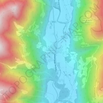
Name: Uttenheim - Villa Ottone topographic map, elevation, terrain.
Average elevation: 1,260 m
Minimum elevation: 827 m
Maximum elevation: 2,069 m
Make a donation
Gear up for your next adventure:
As an Amazon Associate, this site earns from qualifying purchases at no extra cost to you.
Other topographic maps
Click on a map to view its topography, its elevation and its terrain.
Karer See - Lago di Carezza
Italy > Trentino-Alto Adige/Südtirol > South Tyrol > Karersee - Carezza
The lake is located in the western Dolomites on the edge of the Latemarwald, just 20 kilometers southeast of Bolzano at 1520 m altitude in the municipality Welschnofen. The nearest settlement is Carezza. The roughly 300 m long and 140 m wide stretch of water is fed by underground springs from the Latemar…
Average elevation: 1,606 m
Make a donation
Gear up for your next adventure:
As an Amazon Associate, this site earns from qualifying purchases at no extra cost to you.
Villnößtal - Val di Funes
Italy > Trentino-Alto Adige/Südtirol > South Tyrol
Average elevation: 1,590 m
Antholzer See - Lago di Anterselva
Italy > Trentino-Alto Adige/Südtirol > South Tyrol > Rasen-Antholz - Rasun-Anterselva
Average elevation: 1,890 m
Make a donation
Gear up for your next adventure:
As an Amazon Associate, this site earns from qualifying purchases at no extra cost to you.
Etsch - Adige
Italy > Trentino-Alto Adige/Südtirol > South Tyrol > Tarnell - Tarnello > Oberplatz
Average elevation: 1,075 m
Marèo - Enneberg - Marebbe
Italy > Trentino-Alto Adige/Südtirol > South Tyrol
Average elevation: 1,878 m
Welsberg-Taisten - Monguelfo-Tesido
Italy > Trentino-Alto Adige/Südtirol > South Tyrol > Welsberg-Taisten - Monguelfo-Tesido
Average elevation: 1,569 m
Make a donation
Gear up for your next adventure:
As an Amazon Associate, this site earns from qualifying purchases at no extra cost to you.
Etsch - Adige
Italy > Trentino-Alto Adige/Südtirol > South Tyrol > Tarnell - Tarnello
Average elevation: 1,083 m
Sankt Pankraz - San Pancrazio
Italy > Trentino-Alto Adige/Südtirol > South Tyrol > Sankt Pankraz - San Pancrazio
Average elevation: 1,385 m
Make a donation
Gear up for your next adventure:
As an Amazon Associate, this site earns from qualifying purchases at no extra cost to you.