Geolocate

Chimba topographic map

Click on the map to display elevation.

About this map

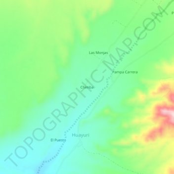
Name: Chimba topographic map, elevation, terrain.

Location: Chimba, Huayuri, Santa Cruz, Province of Palpa, Ica, Peru (-14.54619 -75.30521 -14.50619 -75.26521)

Average elevation: 475 m

Minimum elevation: 395 m

Maximum elevation: 646 m

Gear up for your next adventure:

🥾Mountaineering Boots - Supportive boots for climbing and high-altitude hiking
🛌Insulated Sleeping Pad - Critical thermal barrier between you and the cold ground
🛶Waterproof Dry Bags - Keep electronics and clothes dry during river crossings
🌬️Windproof Camp Stove - Efficient cooking even on exposed mountain peaks
🧭GPS Tracker - Track your location in remote areas safely

As an Amazon Associate, this site earns from qualifying purchases at no extra cost to you.