
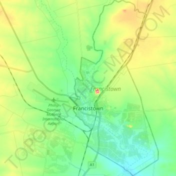
Francistown topographic map
Interactive map
Click on the map to display elevation.
Francistown topographic map, elevation, terrain
About this map
Name: Francistown topographic map, elevation, terrain.
Location: Francistown, Botswana (-21.22269 27.48601 -21.07598 27.56526)
Average elevation: 1,008 m
Minimum elevation: 967 m
Maximum elevation: 1,089 m
Other topographic maps
Click on a map to view its topography, its elevation and its terrain.
Gaborone
Gaborone is situated at 24°39′29″S 25°54′44″E / 24.65806°S 25.91222°E / -24.65806; 25.91222 between Kgale and Oodi Hills, on the Notwane River in the south-eastern corner of Botswana, and 15 kilometres (9.3 mi) from the South African border. The city lies at an elevation of 1,010 metres…
Average elevation: 1,034 m
Gaborone
Botswana > South-East District
Gaborone is situated at 24°39′29″S 25°54′44″E / 24.65806°S 25.91222°E / -24.65806; 25.91222 between Kgale and Oodi Hills, on the Notwane River in the south-eastern corner of Botswana, and 15 kilometres (9.3 mi) from the South African border[15] The city lies at an elevation of 1,010 metres…
Average elevation: 1,032 m