
Warburg topographic map
Interactive map
Click on the map to display elevation.
About this map
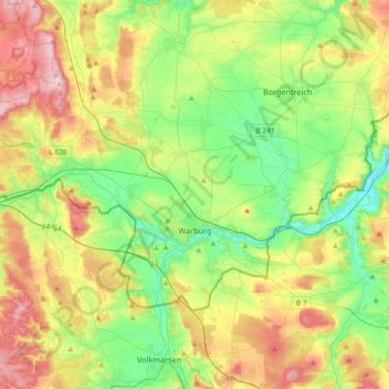
Name: Warburg topographic map, elevation, terrain.
Location: Warburg, Kreis Höxter, North Rhine-Westphalia, 34414, Germany (51.44169 8.90429 51.57833 9.27108)
Average elevation: 248 m
Minimum elevation: 134 m
Maximum elevation: 441 m
Other topographic maps
Click on a map to view its topography, its elevation and its terrain.
Warburg
Germany > North Rhine-Westphalia > Kreis Höxter > Warburg > Warburg
Warburg, Kreis Höxter, North Rhine-Westphalia, 34414, Germany
Average elevation: 212 m