Geolocate

Province of Ilo topographic map

Click on the map to display elevation.

About this map

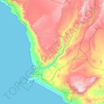
Name: Province of Ilo topographic map, elevation, terrain.

Location: Province of Ilo, Moquegua, Peru (-17.82148 -71.49080 -17.25172 -70.90717)

Average elevation: 652 m

Minimum elevation: 0 m

Maximum elevation: 1,803 m

Other topographic maps

Click on a map to view its topography, its elevation and its terrain.

Quellaveco

Peru > Moquegua > Torata

Average elevation: 3,861 m

Asana

Peru > Moquegua

Average elevation: 4,638 m

Calientes

Peru > Moquegua

Average elevation: 3,040 m

Quellaveco

Peru > Moquegua

Average elevation: 3,861 m

Rincon

Peru > Moquegua > Yacango

Average elevation: 2,161 m

Colana

Peru > Moquegua > Carumas > Ataspaya

Average elevation: 3,046 m

Layme

Peru > Moquegua > Ubinas

Average elevation: 4,137 m

Bentrellata

Peru > Moquegua > Moquegua

Average elevation: 1,261 m

Las Lechuzas

Peru > Moquegua > Moquegua

Average elevation: 1,331 m

Yurac Kancha

Peru > Moquegua > Ubinas

Average elevation: 4,514 m

Ilo

Peru > Moquegua > Ilo > Ilo

Average elevation: 74 m

Toquepala Caves

Peru > Moquegua > Moquegua

Situated in the western Andes, they are in the Moquegua Region of the Osmore River. Located at an elevation of 2,200 m (7,200 ft) (2,800 m (9,200 ft) is also mentioned in another source[1]), they are two small caves each 15 m × 5 m (49 ft × 16 ft) in size, with a depth of 5 m (16 ft). The two Toquepala Caves…

Average elevation: 2,258 m

Gear up for your next adventure:

🥾Trail Running Shoes - Lightweight and durable shoes for trail running
🧶550 Survival Paracord - Versatile utility cord for emergency repairs and rigging
🧰Survival Kit - Essential gear for emergencies in the wilderness
🥾Waterproof Hiking Boots - Boots keeping your feet dry in wet conditions
🥾Durable Hiking Shoes - Long-lasting shoes for frequent hiking

As an Amazon Associate, this site earns from qualifying purchases at no extra cost to you.