
Make a donation
Gear up for your next adventure:
As an Amazon Associate, this site earns from qualifying purchases at no extra cost to you.
Kalay topographic map
Click on the map to display elevation.
Make a donation
Gear up for your next adventure:
As an Amazon Associate, this site earns from qualifying purchases at no extra cost to you.
Kalay
Geographically, the distinctive feature of the town is that the Tropic of Cancer passes through it. This point has been marked by the milepost 55/56 near Kyansitgon village. Set in terrain that has an average elevation of 450 feet (140 m) above mean sea level, the town has a picturesque backdrop of the Laytha Hill in the east and the Chin Hills in the west.
Make a donation
Gear up for your next adventure:
As an Amazon Associate, this site earns from qualifying purchases at no extra cost to you.
About this map
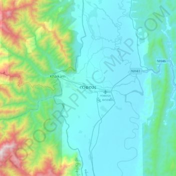
Name: Kalay topographic map, elevation, terrain.
Average elevation: 419 m
Minimum elevation: 96 m
Maximum elevation: 2,140 m
Make a donation
Gear up for your next adventure:
As an Amazon Associate, this site earns from qualifying purchases at no extra cost to you.