Geolocate

Pulinjal topographic map

Click on the map to display elevation.

About this map

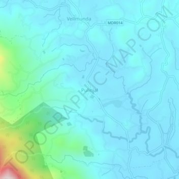
Name: Pulinjal topographic map, elevation, terrain.

Location: Pulinjal, Mananthavady, Wayanad, Kerala, 670731, India (11.69803 75.91862 11.73803 75.95862)

Average elevation: 807 m

Minimum elevation: 721 m

Maximum elevation: 1,402 m

Other topographic maps

Click on a map to view its topography, its elevation and its terrain.

Mazhuvannoor

India > Kerala > Mananthavady > Mazhuvannur

Average elevation: 733 m

Kattikulam

India > Kerala > Mananthavady > Kattikkulam

Average elevation: 772 m

Vellamunda

India > Kerala > Mananthavady > Peechamcode

Average elevation: 812 m

Gear up for your next adventure:

🧥Waterproof Hiking Jacket - Protect yourself from rain and wind while hiking
🥽Outdoor Goggles - Protective eyewear for outdoor activities
🧥Softshell Hiking Jacket - The perfect balance of wind protection and breathability
🛶Waterproof Dry Bags - Keep electronics and clothes dry during river crossings
🧭GPS Outdoor Watch - Smart watch for navigation and fitness tracking in nature

As an Amazon Associate, this site earns from qualifying purchases at no extra cost to you.