Geolocate

West End topographic map

Click on the map to display elevation.

About this map

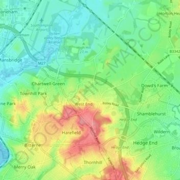
Name: West End topographic map, elevation, terrain.

Location: West End, Eastleigh, Hampshire, England, United Kingdom (50.90433 -1.35900 50.95782 -1.30348)

Average elevation: 31 m

Minimum elevation: 0 m

Maximum elevation: 87 m

Other topographic maps

Click on a map to view its topography, its elevation and its terrain.

Hatch Grange

United Kingdom > England > Hampshire > Eastleigh > West End

Average elevation: 39 m

Gear up for your next adventure:

🥾Trail Hiking Boots - Supportive boots for rough trails
👟Sport Hiking Sandals - Breathable footwear for water crossings and camp rest
🗺️Topographic Maps - Detailed maps to explore trails, mountains, and wilderness areas
🥾Waterproof Hiking Shoes - Durable shoes for wet and rugged trails
🧢Sun Hat - Wide-brim hat for sun protection

As an Amazon Associate, this site earns from qualifying purchases at no extra cost to you.