Geolocate

Brighton topographic map

Click on the map to display elevation.

About this map

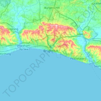
Name: Brighton topographic map, elevation, terrain.

Location: Brighton, Brighton and Hove, England, BN1 1HH, United Kingdom (50.66146 -0.30006 50.98146 0.01994)

Average elevation: 28 m

Minimum elevation: -2 m

Maximum elevation: 252 m

Other topographic maps

Click on a map to view its topography, its elevation and its terrain.

Brighton

United Kingdom > England > Brighton and Hove

Average elevation: 64 m

Hove Park

United Kingdom > England > Brighton and Hove > Hove

Average elevation: 53 m

Hove

United Kingdom > England > Brighton and Hove

Average elevation: 54 m

BN2 4PG

United Kingdom > England > Brighton and Hove > Brighton

Average elevation: 93 m

BN2 0QU

United Kingdom > England > Brighton and Hove > Brighton

Average elevation: 44 m

Gear up for your next adventure:

🧥Fleece Jacket - Warm and lightweight jacket for layering
🧢Outdoor Cap - Protective cap for sun and rain during hikes
🥾Mountain Trail Shoes - High-traction shoes for mountain trails
🛰️Satellite Messenger - Emergency communication for areas with no cell service
🧦Hiking Liner Socks - Thin base layer to prevent friction and blisters

As an Amazon Associate, this site earns from qualifying purchases at no extra cost to you.