
Filandia topographic map
Click on the map to display elevation.
Filandia
Filandia is the northernmost town of the Department of Quindío. The town is located on the west slope of the Cordillera Central of the Colombian Andes, on the Alto Cauca basin and the Rio La Vieja sub-basin. The main urban area is located at an altitude of 1923 metres above sea level and the altitude range of the municipality is between 1300 and 2200 metres above sea level.
About this map
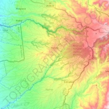
Name: Filandia topographic map, elevation, terrain.
Location: Filandia, Fría, Quindío, RAP Eje Cafetero, 634001, Colombia (4.60645 -75.74745 4.72138 -75.57070)
Average elevation: 1,704 m
Minimum elevation: 1,255 m
Maximum elevation: 2,346 m
Other topographic maps
Click on a map to view its topography, its elevation and its terrain.