
Make a donation
Gear up for your next adventure:
As an Amazon Associate, this site earns from qualifying purchases at no extra cost to you.
IJlst topographic map
Click on the map to display elevation.
Make a donation
Gear up for your next adventure:
As an Amazon Associate, this site earns from qualifying purchases at no extra cost to you.
IJlst
Sinds oktober 2004 was er een discussie gaande over het behoud van de oude fabrieksschoorsteen. In 2007 werd de schoorsteen gerenoveerd, waarbij deze tot de oorspronkelijke hoogte is teruggebracht. Echter niet zoals vroeger gemetseld, maar in de vorm van een stalen skeletsel (kunstwerk). Medio 2005 is er op het oude fabrieksterrein een nieuw woonwijkje verrezen. Verder zijn er nog een vijftal panden voor de oude Nooitgedagt-fabriek gebouwd.
Make a donation
Gear up for your next adventure:
As an Amazon Associate, this site earns from qualifying purchases at no extra cost to you.
About this map
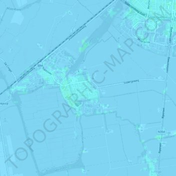
Name: IJlst topographic map, elevation, terrain.
Location: IJlst, Súdwest-Fryslân, Fryslân, Nederland (52.99416 5.60740 53.02566 5.65319)
Average elevation: -1 m
Minimum elevation: -5 m
Maximum elevation: 2 m
Make a donation
Gear up for your next adventure:
As an Amazon Associate, this site earns from qualifying purchases at no extra cost to you.
Other topographic maps
Click on a map to view its topography, its elevation and its terrain.
Make a donation
Gear up for your next adventure:
As an Amazon Associate, this site earns from qualifying purchases at no extra cost to you.
Make a donation
Gear up for your next adventure:
As an Amazon Associate, this site earns from qualifying purchases at no extra cost to you.
Make a donation
Gear up for your next adventure:
As an Amazon Associate, this site earns from qualifying purchases at no extra cost to you.
Laaxum
In 1718 stonden er acht huizen in de buurtschap en in 1851 zes. Aan het begin van de twintigste eeuw was Laaxum een plaats met zestien huizen en twee boerderijen, waarin samen meer dan honderd mensen woonden. In het begin van de eenentwintigste stonden er elf huizen en één boerderij. De haven werd ook wel…
Average elevation: 0 m
Make a donation
Gear up for your next adventure:
As an Amazon Associate, this site earns from qualifying purchases at no extra cost to you.
Make a donation
Gear up for your next adventure:
As an Amazon Associate, this site earns from qualifying purchases at no extra cost to you.
Make a donation
Gear up for your next adventure:
As an Amazon Associate, this site earns from qualifying purchases at no extra cost to you.
Make a donation
Gear up for your next adventure:
As an Amazon Associate, this site earns from qualifying purchases at no extra cost to you.
Make a donation
Gear up for your next adventure:
As an Amazon Associate, this site earns from qualifying purchases at no extra cost to you.
Skilleard
Schillaard werd in 1445 vermeld als Scallaert, in 1478 als Schillaerdt, in 1482 als Schellart en in 16e en 17e eeuw als Schillaerd. De plaatsnaam zou mogelijk verwijzen naar een terp (werth) bij een schelpenbank (skil-schelp). Een andere mogelijke betekenis is dat de terp/wierde scheef weglopend was, waarbij…
Average elevation: 0 m
Make a donation
Gear up for your next adventure:
As an Amazon Associate, this site earns from qualifying purchases at no extra cost to you.