Geolocate

Riglos topographic map

Click on the map to display elevation.

About this map

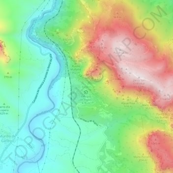
Name: Riglos topographic map, elevation, terrain.

Location: Riglos, Las Peñas de Riglos, Hoya de Huesca / Plana de Uesca, Huesca, Aragon, 22808, Spain (42.32827 -0.74673 42.36827 -0.70673)

Average elevation: 726 m

Minimum elevation: 450 m

Maximum elevation: 1,162 m

Other topographic maps

Click on a map to view its topography, its elevation and its terrain.

Gear up for your next adventure:

🧢Sun Hat - Wide-brim hat for sun protection
🪑Insulated Seat Pad - Protect your seat from cold rocks and wet logs
🛏️Sleeping Bag - Warm and compact sleeping bags for outdoor camping
🔥Emergency Fire Starter - Reliable ignition source for all weather conditions
🕶️Polarized Sunglasses - Protect your eyes with durable polarized lenses

As an Amazon Associate, this site earns from qualifying purchases at no extra cost to you.