Geolocate

Town Bluff topographic map

Click on the map to display elevation.

About this map

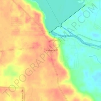
Name: Town Bluff topographic map, elevation, terrain.

Location: Town Bluff, Tyler County, Texas, United States (30.76798 -94.20047 30.80798 -94.16047)

Average elevation: 45 m

Minimum elevation: 15 m

Maximum elevation: 72 m

Other topographic maps

Click on a map to view its topography, its elevation and its terrain.

Woodville

United States > Texas > Tyler County

Average elevation: 84 m

Ivanhoe

United States > Texas > Tyler County

Average elevation: 60 m

Colmesneil

United States > Texas > Tyler County

Average elevation: 89 m

Woodville

United States > Texas > Tyler County

Average elevation: 84 m

Woodville

United States > Texas > Tyler County

Average elevation: 84 m

Woodville

United States > Texas > Tyler County

Average elevation: 84 m

Woodville

United States > Texas > Tyler County

Average elevation: 84 m

Colmesneil

United States > Texas > Tyler County

Average elevation: 89 m

Woodville

United States > Texas > Tyler County

Average elevation: 84 m

Gear up for your next adventure:

Camping Coffee Maker - Brew fresh coffee anywhere on the topographic map
🧦Outdoor Socks - Durable socks designed for hiking and outdoor sports
🥾Trail Hiking Boots - Supportive boots for rough trails
🎒Hiking Daypack - Lightweight and durable backpacks for day trips and excursions
🥾Waterproof Hiking Shoes - Durable shoes for wet and rugged trails

As an Amazon Associate, this site earns from qualifying purchases at no extra cost to you.