Geolocate

Ivanhoe topographic map

Click on the map to display elevation.

About this map

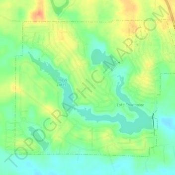
Name: Ivanhoe topographic map, elevation, terrain.

Location: Ivanhoe, Tyler County, Texas, United States (30.66618 -94.43296 30.69324 -94.39297)

Average elevation: 60 m

Minimum elevation: 40 m

Maximum elevation: 86 m

Other topographic maps

Click on a map to view its topography, its elevation and its terrain.

Colmesneil

United States > Texas > Tyler County

Average elevation: 89 m

Woodville

United States > Texas > Tyler County

Average elevation: 84 m

Town Bluff

United States > Texas > Tyler County

Average elevation: 45 m

Warren

United States > Texas > Tyler County

Average elevation: 49 m

Gear up for your next adventure:

🥤Collapsible Travel Cup - Saves space and weight in your mess kit
🧢Hiking Hat - Sun-protective and breathable hats for long treks
🧥Fleece Jacket - Warm and lightweight jacket for layering
🥾Hiking Shoes - Durable and comfortable shoes for trail hiking
🧳Compression Sacks - Maximize space in your backpack by shrinking gear

As an Amazon Associate, this site earns from qualifying purchases at no extra cost to you.