
Make a donation
Gear up for your next adventure:
As an Amazon Associate, this site earns from qualifying purchases at no extra cost to you.
Haus Escherde topographic map
Click on the map to display elevation.
Make a donation
Gear up for your next adventure:
As an Amazon Associate, this site earns from qualifying purchases at no extra cost to you.
About this map
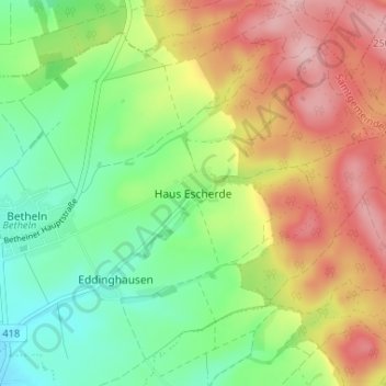
Name: Haus Escherde topographic map, elevation, terrain.
Average elevation: 161 m
Minimum elevation: 83 m
Maximum elevation: 262 m
Make a donation
Gear up for your next adventure:
As an Amazon Associate, this site earns from qualifying purchases at no extra cost to you.
Other topographic maps
Click on a map to view its topography, its elevation and its terrain.
Banteln
Deutschland > Niedersachsen > Landkreis Hildesheim > Gronau
Banteln liegt im Leinebergland östlich vom Naturpark Weserbergland Schaumburg-Hameln und wird von der Leine durchflossen. Es befindet sich südlich von Elze und südwestlich von Gronau. Der Höhenzug Külf, in dem der Aussichtsturm Cölleturm steht, erstreckt sich südlich.
Average elevation: 106 m
Make a donation
Gear up for your next adventure:
As an Amazon Associate, this site earns from qualifying purchases at no extra cost to you.