
Make a donation
Gear up for your next adventure:
As an Amazon Associate, this site earns from qualifying purchases at no extra cost to you.
Brüggen topographic map
Click on the map to display elevation.
Make a donation
Gear up for your next adventure:
As an Amazon Associate, this site earns from qualifying purchases at no extra cost to you.
About this map
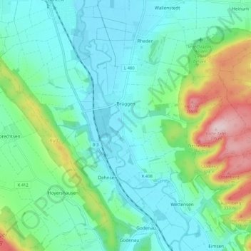
Name: Brüggen topographic map, elevation, terrain.
Average elevation: 153 m
Minimum elevation: 77 m
Maximum elevation: 391 m
Make a donation
Gear up for your next adventure:
As an Amazon Associate, this site earns from qualifying purchases at no extra cost to you.
Other topographic maps
Click on a map to view its topography, its elevation and its terrain.
Wallenstedt
Deutschland > Niedersachsen > Landkreis Hildesheim > Gronau
Wallenstedt liegt 1 km nordöstlich von Rheden und 2,5 km südsüdöstlich von Gronau. Heinum liegt etwa 2 km östlich an der Kreisstraße K 415. Am Rand von Wallenstedt mündet die Heinumer Leine in den Rodebach. Der Segelflugplatz „An den Sieben Bergen“ liegt gut 1 km südöstlich des Ortes am Nordrand…
Average elevation: 117 m