
Folkestone topographic map
Click on the map to display elevation.
About this map
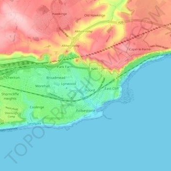
Name: Folkestone topographic map, elevation, terrain.
Average elevation: 62 m
Minimum elevation: 0 m
Maximum elevation: 189 m
Other topographic maps
Click on a map to view its topography, its elevation and its terrain.
Park Gate
United Kingdom > England > Kent > Folkestone and Hythe District > Elham
Average elevation: 130 m
Greatstone beach
United Kingdom > England > Kent > Folkestone and Hythe District > New Romney > Littlestone on Sea
Average elevation: 2 m
The Warren
United Kingdom > England > Kent > Folkestone and Hythe District > Folkestone
Average elevation: 46 m
Greatstone on Sea
United Kingdom > England > Kent > Folkestone and Hythe District > New Romney
Average elevation: 2 m
Ottinge
United Kingdom > England > Kent > Folkestone and Hythe District > Elham
Average elevation: 133 m
Sandling
United Kingdom > England > Kent > Folkestone and Hythe District > Saltwood
Average elevation: 77 m