Geolocate

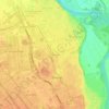
Arbon topographic map

Click on the map to display elevation.

About this map

Name: Arbon topographic map, elevation, terrain.

Location: Arbon, Saint-Gaudens, Haute-Garonne, Occitania, Metropolitan France, 31160, France (42.99215 0.71142 43.01135 0.75156)

Average elevation: 581 m

Minimum elevation: 416 m

Maximum elevation: 821 m

Other topographic maps

Click on a map to view its topography, its elevation and its terrain.
Toulouse

France > Occitania > Haute-Garonne > Toulouse

Average elevation: 173 m

Grand-Noble

France > Occitania > Haute-Garonne > Blagnac

Average elevation: 141 m

Gear up for your next adventure:

🧢Sun Protection Cap - Breathable cap to protect from sun exposure
🛁Quick-Dry Microfiber Towel - Space-saving towel that dries rapidly on the move
💡Solar Camping Lamp - Eco-friendly lighting for campsites
🧥Ultralight Puffy Jacket - Maximum warmth that packs down to the size of an orange
💧Collapsible Water Bottle - Space-saving water bottle for outdoor activities

As an Amazon Associate, this site earns from qualifying purchases at no extra cost to you.