
Make a donation
Gear up for your next adventure:
As an Amazon Associate, this site earns from qualifying purchases at no extra cost to you.
Winterbach topographic map
Click on the map to display elevation.
Make a donation
Gear up for your next adventure:
As an Amazon Associate, this site earns from qualifying purchases at no extra cost to you.
Winterbach
Die Gemeinde Winterbach mit 7602 Einwohnern besteht neben dem Hauptort Winterbach im Remstal mit seinen 7196 Einwohnern aus den Ortsteilen Engelberg am Anstieg zum Schurwald und Manolzweiler auf dessen Höhe (Stand Einwohnerzahlen: Ende 2015). Nördlich der Ortsgrenze des Dorfes Winterbach liegen entlang der Straße Vorderer Wattenbach wenige Aussiedlerhöfe, an einem Südhang wird dort Wein angebaut.
Make a donation
Gear up for your next adventure:
As an Amazon Associate, this site earns from qualifying purchases at no extra cost to you.
About this map
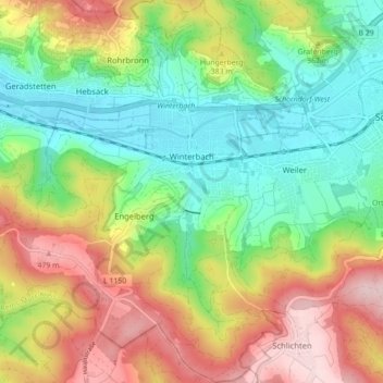
Name: Winterbach topographic map, elevation, terrain.
Average elevation: 345 m
Minimum elevation: 235 m
Maximum elevation: 504 m
Make a donation
Gear up for your next adventure:
As an Amazon Associate, this site earns from qualifying purchases at no extra cost to you.
Other topographic maps
Click on a map to view its topography, its elevation and its terrain.
Kirchenkirnberg
Deutschland > Baden-Württemberg > Rems-Murr-Kreis > Murrhardt
Average elevation: 480 m
Stöckenhof
Deutschland > Baden-Württemberg > Rems-Murr-Kreis > Berglen > Öschelbronn
Average elevation: 362 m
Make a donation
Gear up for your next adventure:
As an Amazon Associate, this site earns from qualifying purchases at no extra cost to you.
Make a donation
Gear up for your next adventure:
As an Amazon Associate, this site earns from qualifying purchases at no extra cost to you.
Hertmannsweiler
Deutschland > Baden-Württemberg > Rems-Murr-Kreis > Winnenden > Hertmannsweiler
Average elevation: 329 m
Vordersteinenberg
Deutschland > Baden-Württemberg > Rems-Murr-Kreis > Alfdorf > Vordersteinenberg
Average elevation: 489 m
Zwingelhausen
Deutschland > Baden-Württemberg > Rems-Murr-Kreis > Kirchberg an der Murr
Average elevation: 302 m
Make a donation
Gear up for your next adventure:
As an Amazon Associate, this site earns from qualifying purchases at no extra cost to you.