Geolocate

Struer topographic map

Click on the map to display elevation.

About this map

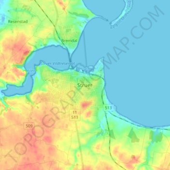
Name: Struer topographic map, elevation, terrain.

Location: Struer, Struer Municipality, Central Denmark Region, 7600, Denmark (56.44668 8.55514 56.52668 8.63514)

Average elevation: 15 m

Minimum elevation: -2 m

Maximum elevation: 43 m

Other topographic maps

Click on a map to view its topography, its elevation and its terrain.

Glesborg

Denmark > Central Denmark Region

Average elevation: 39 m

Nørrestrand

Denmark > Central Denmark Region > Horsens

Average elevation: 14 m

Samsø

Denmark > Central Denmark Region

Average elevation: 2 m

Begtrup Vig

Denmark > Central Denmark Region

Average elevation: 9 m

Anholt

Denmark > Central Denmark Region

The western fifth of Anholt consists of hilly moraine country, while the eastern four-fifths of the island consist of mostly flat raised seabed with some low hills, former wind-blown sand dunes. Only the western moraine hills are inhabited. The eastern part, called "Ørkenen" (The Desert) is treeless; the…

Average elevation: 2 m

Rimsø

Denmark > Central Denmark Region

Average elevation: 32 m

Tunø

Denmark > Central Denmark Region

Average elevation: 2 m

Mølleparken

Denmark > Central Denmark Region > Aarhus

Average elevation: 17 m

Karup Å

Denmark > Central Denmark Region

Average elevation: 57 m

Julsø

Denmark > Central Denmark Region > Laven

Average elevation: 65 m

Knebel Bro

Denmark > Central Denmark Region

Average elevation: 12 m

Gear up for your next adventure:

🧦Thermal Socks - Warm socks for winter hiking or camping
🧥Waterproof Hiking Jacket - Protect yourself from rain and wind while hiking
🧼Biodegradable Camp Soap - Environmentally friendly cleaning for gear and body
👖Convertible Hiking Pants - Zip-off legs to adapt to changing weather conditions
🪑Ultralight Camping Stool - Compact seating for rest stops during long hikes

As an Amazon Associate, this site earns from qualifying purchases at no extra cost to you.