
Make a donation
Gear up for your next adventure:
As an Amazon Associate, this site earns from qualifying purchases at no extra cost to you.
Niederstimm topographic map
Click on the map to display elevation.
Make a donation
Gear up for your next adventure:
As an Amazon Associate, this site earns from qualifying purchases at no extra cost to you.
About this map
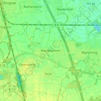
Name: Niederstimm topographic map, elevation, terrain.
Average elevation: 367 m
Minimum elevation: 358 m
Maximum elevation: 373 m
Make a donation
Gear up for your next adventure:
As an Amazon Associate, this site earns from qualifying purchases at no extra cost to you.
Other topographic maps
Click on a map to view its topography, its elevation and its terrain.
Baar-Ebenhausen
Deutschland > Bayern > Landkreis Pfaffenhofen an der Ilm
Seit 2011 ist der Bahnhof Baar-Ebenhausen im Ortsteil Ebenhausen an der Bahnstrecke München–Treuchtlingen in Betrieb. Zuvor gab es weiter südlich in Baar einen Bahnhof, der aber seit jeher den Namen des benachbarten Reichertshofen trug. Um höhere Geschwindigkeiten in diesem Abschnitt zu erreichen, wurde…
Average elevation: 374 m
Manching
Deutschland > Bayern > Landkreis Pfaffenhofen an der Ilm
Es gab 2018 nach der amtlichen Statistik 7582 sozialversicherungspflichtig Beschäftigte am Arbeitsort. Sozialversicherungspflichtig Beschäftigte am Wohnort gab es insgesamt 5835, so dass die Zahl der Einpendler um 1747 höher war als die Zahl der Auspendler. 2016 gab es 53 landwirtschaftliche Betriebe, die…
Average elevation: 367 m
Make a donation
Gear up for your next adventure:
As an Amazon Associate, this site earns from qualifying purchases at no extra cost to you.