Geolocate

Ivanhoe topographic map

Click on the map to display elevation.

About this map

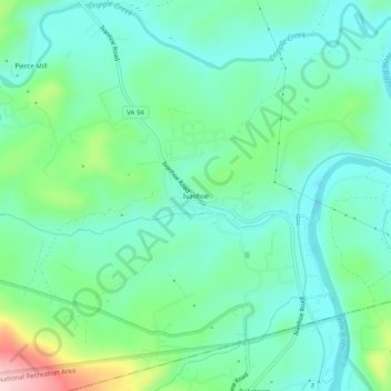
Name: Ivanhoe topographic map, elevation, terrain.

Location: Ivanhoe, Wythe County, Virginia, 24350, United States (36.82012 -80.98675 36.86012 -80.94675)

Average elevation: 643 m

Minimum elevation: 578 m

Maximum elevation: 837 m

Other topographic maps

Click on a map to view its topography, its elevation and its terrain.

Rural Retreat

United States > Virginia > Wythe County

Average elevation: 777 m

Gear up for your next adventure:

🧤Thermal Hiking Gloves - Grip-enhanced gloves for cold-weather altitude trekking
🛶Canoe Life Vest - Safety vest for water sports
🔦UV Flashlight - Detect minerals or specific insects in the dark
🧦Hiking Socks - Moisture-wicking and comfortable socks for long hikes
🧰Survival Kit - Essential gear for emergencies in the wilderness

As an Amazon Associate, this site earns from qualifying purchases at no extra cost to you.