
Panabo topographic map
Click on the map to display elevation.
About this map
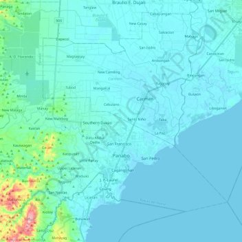
Name: Panabo topographic map, elevation, terrain.
Location: Panabo, Davao del Norte, Davao Region, 8105, Philippines (7.22119 125.54644 7.45090 125.73904)
Average elevation: 18 m
Minimum elevation: 0 m
Maximum elevation: 225 m
Other topographic maps
Click on a map to view its topography, its elevation and its terrain.
Tagum
One of the significant accomplishments of the officialdom of Tagum during the 1990s was its elevation from a second to the first-class municipality. This opened a gateway to increase its financial resources through the Internal Revenue Allocation (IRA) from the national government and local revenues. This was…
Average elevation: 103 m
Pantaron Range
Philippines > Davao del Norte > Kapalong
This article related to topography is a stub. You can help Wikipedia by expanding it.
Average elevation: 409 m
Faith Tabernacle Church Sto. Tomas
Philippines > Davao del Norte > Santo Tomas
Average elevation: 36 m