Geolocate

Panabo topographic map

Click on the map to display elevation.

About this map

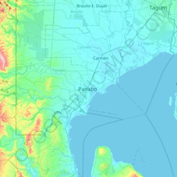
Name: Panabo topographic map, elevation, terrain.

Location: Panabo, Davao del Norte, Davao Region, 8105, Philippines (7.14519 125.52457 7.46519 125.84457)

Average elevation: 30 m

Minimum elevation: -1 m

Maximum elevation: 313 m

Other topographic maps

Click on a map to view its topography, its elevation and its terrain.

Lasang River

Philippines > Davao del Norte > Panabo

Average elevation: 8 m

Bunawan River

Philippines > Davao del Norte > Panabo

Average elevation: 61 m

Gear up for your next adventure:

👖Convertible Hiking Pants - Zip-off legs to adapt to changing weather conditions
🔨Vehicle Emergency Tool - Safety tool for remote road trips to trailheads
🔋Lithium AA Batteries - Long-lasting power that performs in extreme cold
🧤Rechargeable Heated Gloves - Extreme warmth for Canadian winter expeditions
🧢Hiking Sun Hat - Wide-brimmed protection for exposed mountain ridges

As an Amazon Associate, this site earns from qualifying purchases at no extra cost to you.