
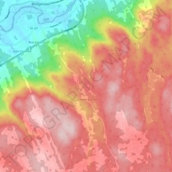
Carleton Corner topographic map
Interactive map
Click on the map to display elevation.
About this map
Name: Carleton Corner topographic map, elevation, terrain.
Average elevation: 159 m
Minimum elevation: -5 m
Maximum elevation: 261 m
Routes: Municipality of the County of Annapolis GPS tracks, routes, trails, hikes
Other topographic maps
Click on a map to view its topography, its elevation and its terrain.
Frasertown
Canada > Nova Scotia > Municipality of the County of Annapolis > Princedale
Average elevation: 138 m
Upper Granville
Canada > Nova Scotia > Municipality of the County of Annapolis
Average elevation: 47 m
Granville Ferry
Canada > Nova Scotia > Municipality of the County of Annapolis
Average elevation: 80 m
Bear River
Canada > Nova Scotia > Municipality of the County of Annapolis > Bear River
Average elevation: 95 m
Kejimkujik National Park
Canada > Nova Scotia > Municipality of the County of Annapolis > Kejimkujik National Park of Canada
Average elevation: 121 m
Annapolis River
Canada > Nova Scotia > Municipality of the County of Annapolis
Average elevation: 108 m
Falkland Ridge
Canada > Nova Scotia > Municipality of the County of Annapolis
Average elevation: 170 m
Milbury Lake
Canada > Nova Scotia > Municipality of the County of Annapolis > Youngs Cove
Average elevation: 163 m
North Mountain
Canada > Nova Scotia > Municipality of the County of Annapolis > Port Royal
Average elevation: 134 m
Granville Beach
Canada > Nova Scotia > Municipality of the County of Annapolis > Granville Beach
Average elevation: 76 m
Annapolis Basin
Canada > Nova Scotia > Municipality of the County of Annapolis > Karsdale
Average elevation: 62 m
Black Rattle
Canada > Nova Scotia > Municipality of the County of Annapolis > Cloud Lake
Average elevation: 190 m
Clementsvale
Canada > Nova Scotia > Municipality of the County of Annapolis > Clementsvale
Average elevation: 141 m
Youngs Cove
Canada > Nova Scotia > Municipality of the County of Annapolis > Youngs Cove
Average elevation: 99 m
Brooklyn
Canada > Nova Scotia > Municipality of the County of Annapolis > Brooklyn
Average elevation: 80 m
Lake Pleasant
Canada > Nova Scotia > Municipality of the County of Annapolis > Lake Pleasant
Average elevation: 196 m
Smith Brook
Canada > Nova Scotia > Municipality of the County of Annapolis > Phinneys Cove
Average elevation: 39 m
Lawrencetown
Canada > Nova Scotia > Municipality of the County of Annapolis > Lawrencetown
Average elevation: 29 m
Springfield
Canada > Nova Scotia > Municipality of the County of Annapolis > Springfield
Average elevation: 178 m
Meadowvale
Canada > Nova Scotia > Municipality of the County of Annapolis > Meadowvale
Average elevation: 27 m
Inglisville
Canada > Nova Scotia > Municipality of the County of Annapolis > Inglisville
Average elevation: 184 m