
Make a donation
Gear up for your next adventure:
As an Amazon Associate, this site earns from qualifying purchases at no extra cost to you.
Dixville topographic map
Click on the map to display elevation.
Make a donation
Gear up for your next adventure:
As an Amazon Associate, this site earns from qualifying purchases at no extra cost to you.
Dixville
According to the United States Census Bureau, the township has a total area of 49.2 square miles (127.3 km2), of which 49.0 square miles (126.9 km2) are land and 0.2 square miles (0.4 km2), or 0.35%, are water. Dixville Notch is in the southwest part of the township. With an elevation of 1,887 feet (575 m) above sea level, it is the height of land between west-flowing tributaries of the Connecticut River and east-flowing tributaries of the Androscoggin River. The notch lies within Dixville Notch State Park. (The term "notch" is the local equivalent of "pass" or "gap", and refers to a low place between mountains or mountain ranges.) Nearby Dixville Peak, at 3,482 feet (1,061 m), is the highest point in the township.
Make a donation
Gear up for your next adventure:
As an Amazon Associate, this site earns from qualifying purchases at no extra cost to you.
About this map
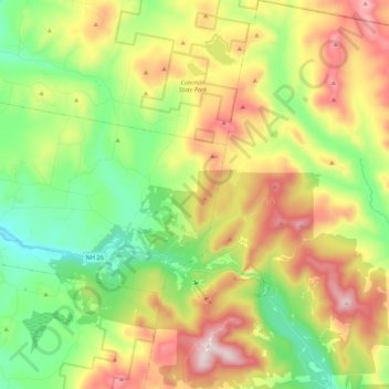
Name: Dixville topographic map, elevation, terrain.
Location: Dixville, Coös County, New Hampshire, United States (44.81834 -71.35341 44.97345 -71.21595)
Average elevation: 635 m
Minimum elevation: 349 m
Maximum elevation: 1,055 m
Make a donation
Gear up for your next adventure:
As an Amazon Associate, this site earns from qualifying purchases at no extra cost to you.
Other topographic maps
Click on a map to view its topography, its elevation and its terrain.
Mount Washington
United States > New Hampshire > Coos County
Mount Washington, also known as Agiocochook, is an ultra-prominent mountain in the state of New Hampshire. It is the highest peak in the Northeastern United States at 6,288.2 ft (1,916.6 m) and the most topographically prominent mountain east of the Mississippi River.
Average elevation: 1,568 m
Mount Washington
United States > New Hampshire > Coos County
Mount Washington, in New Hampshire, is the highest peak in the Northeastern United States at 6,288.2 ft (1,916.6 m) and the most topographically prominent mountain east of the Mississippi River.
Average elevation: 1,568 m
Make a donation
Gear up for your next adventure:
As an Amazon Associate, this site earns from qualifying purchases at no extra cost to you.
Mount Adams
United States > New Hampshire > Coos County
Mount Adams, elevation 5,793 feet (1,766 m) above sea level, is a mountain in New Hampshire, the second highest peak in the Northeast United States after its nearby neighbor, Mount Washington. Located in the northern Presidential Range, Mount Adams was named after John Adams, the second President of the United…
Average elevation: 1,379 m
Make a donation
Gear up for your next adventure:
As an Amazon Associate, this site earns from qualifying purchases at no extra cost to you.
Mount Washington
United States > New Hampshire > Coos County
Mount Washington is an ultra-prominent mountain in the state of New Hampshire. It is the highest peak in the Northeastern United States at 6,288.2 ft (1,916.6 m) and the most topographically prominent mountain east of the Mississippi River.
Average elevation: 1,568 m
Make a donation
Gear up for your next adventure:
As an Amazon Associate, this site earns from qualifying purchases at no extra cost to you.
Mount Washington
United States > New Hampshire > Coos County
Mount Washington, also known as Agiocochook, is an ultra-prominent mountain in the state of New Hampshire. It is the highest peak in the Northeastern United States at 6,288.2 ft (1,916.6 m) and the most topographically prominent mountain east of the Mississippi River.
Average elevation: 1,568 m
Make a donation
Gear up for your next adventure:
As an Amazon Associate, this site earns from qualifying purchases at no extra cost to you.
Make a donation
Gear up for your next adventure:
As an Amazon Associate, this site earns from qualifying purchases at no extra cost to you.