Geolocate

West Milan topographic map

Click on the map to display elevation.

About this map

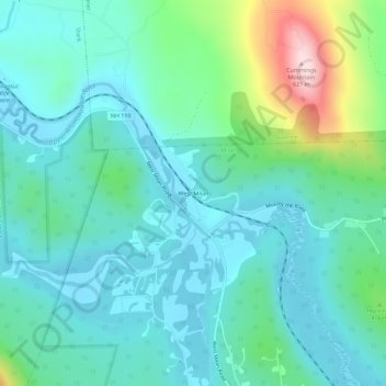
Name: West Milan topographic map, elevation, terrain.

Location: West Milan, Milan, Coös County, New Hampshire, United States (44.57908 -71.32384 44.61908 -71.28384)

Average elevation: 363 m

Minimum elevation: 293 m

Maximum elevation: 625 m

Gear up for your next adventure:

🦶Hiking Shoe Insoles - Added support for high arches and long days on feet
🌡️Emergency Mylar Blankets - Compact thermal protection for unexpected nights outdoors
🔦LED Headlamp - Hands-free lighting for early morning starts or late finishes
Camping Essentials - All-in-one gear for a comfortable camping trip
🧴Outdoor Sunscreen - High SPF protection for high-altitude UV exposure

As an Amazon Associate, this site earns from qualifying purchases at no extra cost to you.