Geolocate

Pigna topographic map

Click on the map to display elevation.

About this map

Name: Pigna topographic map, elevation, terrain.

Location: Pigna, Provincia di Imperia, Liguria, 18037, Italy (43.90073 7.58158 43.99841 7.74135)

Average elevation: 908 m

Minimum elevation: 132 m

Maximum elevation: 2,017 m

Other topographic maps

Click on a map to view its topography, its elevation and its terrain.
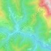
Andagna

Italy > Provincia di Imperia

Average elevation: 726 m

Gear up for your next adventure:

🛶Kayak Accessories - Essential gear for safe and fun kayaking adventures
🔦LED Headlamp - Hands-free lighting for early morning starts or late finishes
🧼Biodegradable Camp Soap - Environmentally friendly cleaning for gear and body
🥾Hiking Shorts - Breathable shorts suitable for summer hikes
🔦LED Headtorch - Bright and durable light for night activities

As an Amazon Associate, this site earns from qualifying purchases at no extra cost to you.