
Make a donation
Gear up for your next adventure:
As an Amazon Associate, this site earns from qualifying purchases at no extra cost to you.
Yathkyed Lake topographic map
Click on the map to display elevation.
Make a donation
Gear up for your next adventure:
As an Amazon Associate, this site earns from qualifying purchases at no extra cost to you.
Yathkyed Lake
It is part of the Hearne Domain, Western Churchill province of the Churchill craton, which is the northwest section of the Canadian Shield. According to the Atlas of Canada the geographical centre of the country lies just south of the lake at 62°24′N 096°28′W / 62.400°N 96.467°W / 62.400; -96.467 (Geographical centre of Canada). Yathkyed lake lies at an elevation of 82 meters (269 feet). Some nearby locations or citites near Yathkyed lake are Windy Point at 9 kilometers south, Cairn Point at 17 kilometers east and Yellowknife at 520 kilometers north.
Make a donation
Gear up for your next adventure:
As an Amazon Associate, this site earns from qualifying purchases at no extra cost to you.
About this map
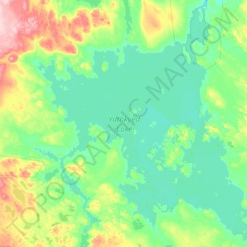
Name: Yathkyed Lake topographic map, elevation, terrain.
Location: Yathkyed Lake, Kivalliq Region, Nunavut, Canada (62.42380 -97.47136 62.47771 -97.39634)
Average elevation: 142 m
Minimum elevation: 139 m
Maximum elevation: 154 m
Make a donation
Gear up for your next adventure:
As an Amazon Associate, this site earns from qualifying purchases at no extra cost to you.
Other topographic maps
Click on a map to view its topography, its elevation and its terrain.