
Korsworm topographic map
Interactive map
Click on the map to display elevation.
About this map
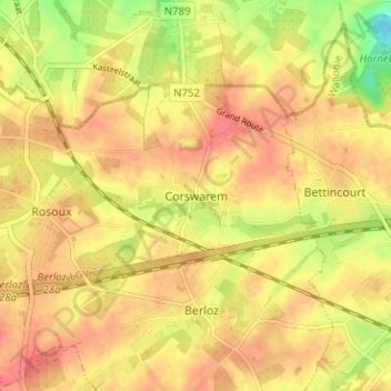
Name: Korsworm topographic map, elevation, terrain.
Location: Korsworm, Berloz, Borgworm, Luik, Wallonië, 4257, België (50.68957 5.19315 50.72957 5.23315)
Average elevation: 123 m
Minimum elevation: 87 m
Maximum elevation: 140 m
Other topographic maps
Click on a map to view its topography, its elevation and its terrain.
Ville-en-Hesbaye
België > Luik > Borgworm > Ville-en-Hesbaye
Ville-en-Hesbaye, Braives, Borgworm, Luik, Wallonië, 4260, België
Average elevation: 146 m