Geolocate

Guisborough topographic map

Click on the map to display elevation.

About this map
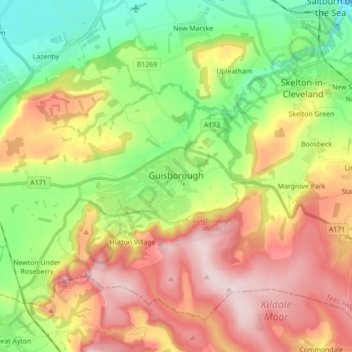
Name: Guisborough topographic map, elevation, terrain.

Location: Guisborough, Redcar and Cleveland, Tees Valley, England, United Kingdom (54.49403 -1.16498 54.57718 -0.98977)

Average elevation: 147 m

Minimum elevation: 0 m

Maximum elevation: 326 m

Other topographic maps

Click on a map to view its topography, its elevation and its terrain.

Stanghow

United Kingdom > England > Redcar and Cleveland

Average elevation: 171 m

Lazenby

United Kingdom > England > Redcar and Cleveland

Average elevation: 66 m

Liverton

United Kingdom > England > Redcar and Cleveland > Loftus

Average elevation: 140 m

Boulby

United Kingdom > England > Redcar and Cleveland > Loftus

Average elevation: 68 m

Gear up for your next adventure:

🔭Compact Binoculars - Lightweight optics for scouting trails and wildlife
🛶Waterproof Dry Bags - Keep electronics and clothes dry during river crossings
🌡️Emergency Mylar Blankets - Compact thermal protection for unexpected nights outdoors
🧰Survival Kit - Essential gear for emergencies in the wilderness
🧭GPS Handheld Device - Reliable GPS navigation for outdoor adventures

As an Amazon Associate, this site earns from qualifying purchases at no extra cost to you.