Geolocate

Vercia topographic map

Click on the map to display elevation.

About this map
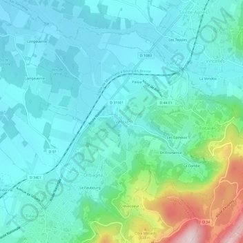
Name: Vercia topographic map, elevation, terrain.

Location: Vercia, Val-Sonnette, Lons-le-Saunier, Jura, Bourgogne-Franche-Comté, France métropolitaine, 39190, France (46.57020 5.43677 46.61020 5.47677)

Average elevation: 269 m

Minimum elevation: 195 m

Maximum elevation: 570 m

Other topographic maps

Click on a map to view its topography, its elevation and its terrain.

Vercia

France > Bourgogne-Franche-Comté > Jura > Val-Sonnette

Average elevation: 226 m

Vincelles

France > Bourgogne-Franche-Comté > Jura > Val-Sonnette

Average elevation: 237 m

Bonnaud

France > Bourgogne-Franche-Comté > Jura > Val-Sonnette

Average elevation: 202 m

Grusse

France > Bourgogne-Franche-Comté > Jura > Val-Sonnette

Average elevation: 366 m

Gear up for your next adventure:

🥫Freeze-Dried Meals - Lightweight, high-calorie nutrition for multi-day treks
🚲Bike Repair Kit - Essential tools for on-trail mechanical issues
🎒Fully Waterproof Backpack - Total protection for photography gear and electronics
🔭Compact Binoculars - Lightweight optics for scouting trails and wildlife
🔭Outdoor Binoculars - Lightweight binoculars for birdwatching and hiking

As an Amazon Associate, this site earns from qualifying purchases at no extra cost to you.