Geolocate

Uthiru ward topographic map

Click on the map to display elevation.

About this map

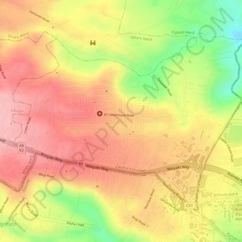
Name: Uthiru ward topographic map, elevation, terrain.

Location: Uthiru ward, Kabete, Kiambu, 29039, Kenya (-1.26505 36.70074 -1.24533 36.72664)

Average elevation: 1,892 m

Minimum elevation: 1,797 m

Maximum elevation: 1,944 m

Other topographic maps

Click on a map to view its topography, its elevation and its terrain.

Gachie

Kenya > Kiambu > Kabete > Kihara ward

Average elevation: 1,777 m

Gitaru

Kenya > Kiambu > Kabete > Gitaru ward

Average elevation: 2,012 m

Gear up for your next adventure:

🧥Waterproof Jacket - Lightweight rain jackets for hiking and outdoor activities
Bushcraft Tarp - Versatile emergency shelter or gear protection
🔋Emergency Crank Radio - Weather alerts and power without needing batteries
📷Outdoor Action Camera - Capture high-elevation views and rugged adventures
🎒Hiking Backpack - Lightweight and ergonomic backpacks for day hikes or multi-day treks

As an Amazon Associate, this site earns from qualifying purchases at no extra cost to you.