
Bruce Peninsula National Park topographic map
Interactive map
Click on the map to display elevation.
About this map
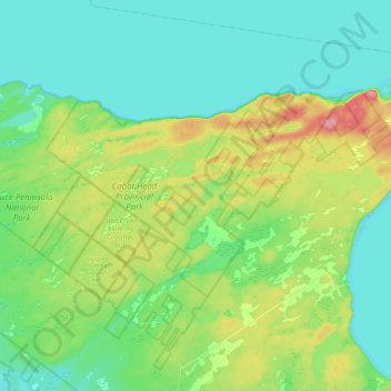
Name: Bruce Peninsula National Park topographic map, elevation, terrain.
Average elevation: 202 m
Minimum elevation: 170 m
Maximum elevation: 279 m
Other topographic maps
Click on a map to view its topography, its elevation and its terrain.
Flowerpot Island
Canada > Ontario > Northern Bruce Peninsula
Flowerpot Island, Northern Bruce Peninsula, Bruce County, Ontario, Canada
Average elevation: 179 m
Tobermory
Canada > Ontario > Northern Bruce Peninsula > Tobermory
Tobermory, Northern Bruce Peninsula, Bruce County, Southwestern Ontario, Ontario, N0H 2R0, Canada
Average elevation: 182 m
Cyprus Lake
Canada > Ontario > Northern Bruce Peninsula
Cyprus Lake, Cyprus Lake Trail, Northern Bruce Peninsula, Bruce County, Ontario, Canada
Average elevation: 193 m
Cape Chin
Canada > Ontario > Northern Bruce Peninsula
Cape Chin, Bruce Trail, Northern Bruce Peninsula, Bruce County, Southwestern Ontario, Ontario, Canada
Average elevation: 184 m