Geolocate

Shurton topographic map

Click on the map to display elevation.

About this map

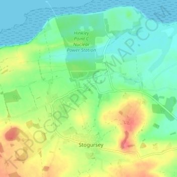
Name: Shurton topographic map, elevation, terrain.

Location: Shurton, Stogursey, Somerset, England, TA5 1QE, United Kingdom (51.17230 -3.16203 51.21230 -3.12203)

Average elevation: 26 m

Minimum elevation: 0 m

Maximum elevation: 73 m

Other topographic maps

Click on a map to view its topography, its elevation and its terrain.

Redham

United Kingdom > England > Somerset > Stogursey > Stolford

Average elevation: 11 m

Gear up for your next adventure:

💡LED Headlamp - Hands-free illumination for night hiking and camping
🥾Trail Running Shoes - Lightweight and durable shoes for trail running
🏃Hydration Running Vest - Carry water and maps close to your body for speed
🥾Lightweight Hiking Shoes - Comfortable shoes for day hikes
🧴Outdoor Sunscreen - High SPF protection for high-altitude UV exposure

As an Amazon Associate, this site earns from qualifying purchases at no extra cost to you.