Geolocate

Slindon topographic map

Click on the map to display elevation.

About this map

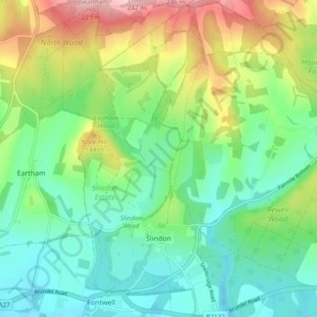
Name: Slindon topographic map, elevation, terrain.

Location: Slindon, Fontwell, Arun, West Sussex, England, United Kingdom (50.85276 -0.65822 50.90588 -0.61201)

Average elevation: 85 m

Minimum elevation: 19 m

Maximum elevation: 222 m

Other topographic maps

Click on a map to view its topography, its elevation and its terrain.

Fontwell

United Kingdom > England > West Sussex > Arun

Average elevation: 31 m

Eastergate

United Kingdom > England > West Sussex > Arun

Average elevation: 12 m

Shripney

United Kingdom > England > West Sussex > Arun

Average elevation: 3 m

Wick

United Kingdom > England > West Sussex > Arun > Littlehampton > Lyminster

Average elevation: 3 m

Eastergate

United Kingdom > England > West Sussex > Arun

Average elevation: 12 m

Barnham

United Kingdom > England > West Sussex > Arun

Average elevation: 6 m

Bognor Regis

United Kingdom > England > West Sussex > Arun > Nyetimber

Average elevation: 2 m

Nyetimber

United Kingdom > England > West Sussex > Arun

Average elevation: 3 m

Lidsey Rife

United Kingdom > England > West Sussex > Arun > Felpham

Average elevation: 3 m

Elmer

United Kingdom > England > West Sussex > Arun

Average elevation: 2 m

North Bersted

United Kingdom > England > West Sussex > Arun

Average elevation: 3 m

Binsted

United Kingdom > England > West Sussex > Arun > Walberton

Average elevation: 23 m

Gear up for your next adventure:

🧦Crew Hiking Socks - Comfortable socks for long-distance hikes
🧥Softshell Hiking Jacket - The perfect balance of wind protection and breathability
🍽️Titanium Camping Spork - Ultralight and indestructible eating utensil
Lightweight Backpacking Tent - Compact tent for efficient hiking trips
🏕️Camping Hammock - Integrated protection for sleeping between trees

As an Amazon Associate, this site earns from qualifying purchases at no extra cost to you.