Geolocate

Sandianes topographic map

Click on the map to display elevation.

About this map

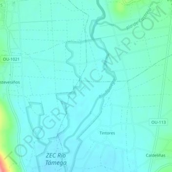
Name: Sandianes topographic map, elevation, terrain.

Location: Sandianes, Tintores, Verín, Orense, Galicia, 32624, España (41.96636 -7.45094 41.98636 -7.43094)

Average elevation: 402 m

Minimum elevation: 387 m

Maximum elevation: 490 m

Other topographic maps

Click on a map to view its topography, its elevation and its terrain.

Cabreiroá

España > Galicia > Verín > Verín

Average elevation: 469 m

Feces de Abaixo

España > Galicia > Verín > Verín

Average elevation: 388 m

Feces de Cima

España > Galicia > Verín > Verín

Average elevation: 547 m

Gear up for your next adventure:

🔋Lithium AA Batteries - Long-lasting power that performs in extreme cold
🥾Waterproof Hiking Boots - Boots keeping your feet dry in wet conditions
🪜Heavy Duty Carabiners - Multi-use clips for securing gear to your backpack
🧴Waterproofing Spray - Restore the DWR coating on jackets and tents
Backpacking Tent - Lightweight tent for long-distance hiking trips

As an Amazon Associate, this site earns from qualifying purchases at no extra cost to you.