Geolocate

Heidelberg topographic map

Click on the map to display elevation.

About this map

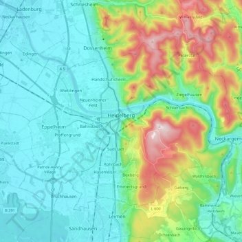
Name: Heidelberg topographic map, elevation, terrain.

Location: Heidelberg, Baden-Württemberg, Germany (49.35200 8.57318 49.45969 8.79405)

Average elevation: 212 m

Minimum elevation: 95 m

Maximum elevation: 576 m

Other topographic maps

Click on a map to view its topography, its elevation and its terrain.

Ibach

Germany > Baden-Württemberg > Landkreis Waldshut

Average elevation: 820 m

Gear up for your next adventure:

🔥Camping Stove - Portable stoves to cook outdoors with ease
Camping Essentials - All-in-one gear for a comfortable camping trip
🥾Hiking Shorts - Breathable shorts suitable for summer hikes
🥾Waterproof Hiking Boots - Boots keeping your feet dry in wet conditions
🥾Mountain Trail Shoes - High-traction shoes for mountain trails

As an Amazon Associate, this site earns from qualifying purchases at no extra cost to you.