Geolocate

Waso ward topographic map

Click on the map to display elevation.

About this map

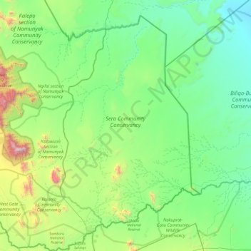
Name: Waso ward topographic map, elevation, terrain.

Location: Waso ward, Samburu East, Samburu, Rift Valley, Kenya (0.56462 37.27803 1.51525 38.07929)

Average elevation: 773 m

Minimum elevation: 352 m

Maximum elevation: 2,634 m

Other topographic maps

Click on a map to view its topography, its elevation and its terrain.

Kalama

Kenya > Samburu > Samburu East > Waso ward

Average elevation: 1,106 m

Sasaab Manyatta

Kenya > Samburu > Samburu East > Wamba West ward

Average elevation: 993 m

Kamanga

Kenya > Samburu > Samburu East > Waso ward

Average elevation: 1,041 m

Ndonyo Uasin

Kenya > Samburu > Samburu East > Waso ward

Average elevation: 760 m

Gear up for your next adventure:

🔋Lithium AA Batteries - Long-lasting power that performs in extreme cold
🔭Compact Monocular - One-handed bird watching and trail spotting
🕶️Polarized Sunglasses - Reduces glare from snow and water at high elevations
🔋Solar Power Bank - Keep your GPS and devices charged during long outdoor trips
🗺️Topographic Maps - Detailed maps to explore trails, mountains, and wilderness areas

As an Amazon Associate, this site earns from qualifying purchases at no extra cost to you.