Geolocate

Tuscania topographic map

Click on the map to display elevation.

About this map

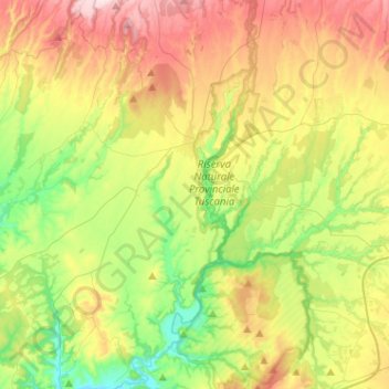
Name: Tuscania topographic map, elevation, terrain.

Location: Tuscania, Viterbo, Lazio, 01017, Italy (42.29875 11.68816 42.48765 11.93217)

Average elevation: 173 m

Minimum elevation: 28 m

Maximum elevation: 380 m

Other topographic maps

Click on a map to view its topography, its elevation and its terrain.

Monte Raschio

Italy > Lazio > Viterbo > Oriolo Romano

Average elevation: 448 m

Bagnaia

Italy > Lazio > Viterbo > Viterbo

Average elevation: 464 m

Isola Bisentina

Italy > Lazio > Viterbo > Capodimonte

Average elevation: 304 m

Cura

Italy > Lazio > Viterbo > Vetralla

Average elevation: 393 m

Gear up for your next adventure:

🩹Compact First Aid Kit - Pre-packed essentials for common trail injuries
🥘Camping Cookware Set - Compact nesting pots and pans for trail cooking
🧴First Aid Kit - Essential first aid supplies for outdoor emergencies
🕶️Polarized Sunglasses - Protect your eyes with durable polarized lenses
👟Trail Running Shoes - Agile footwear for fast-paced topographic exploration

As an Amazon Associate, this site earns from qualifying purchases at no extra cost to you.