Geolocate

Elizabeth Town topographic map

Click on the map to display elevation.

About this map

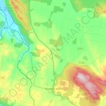
Name: Elizabeth Town topographic map, elevation, terrain.

Location: Elizabeth Town, Meander Valley, Tasmania, 7304, Australia (-41.48494 146.49415 -41.36500 146.63386)

Average elevation: 214 m

Minimum elevation: 42 m

Maximum elevation: 534 m

Other topographic maps

Click on a map to view its topography, its elevation and its terrain.

Cathedral Mountain

Australia > Tasmania

Average elevation: 992 m

Waterworks Reserve

Australia > Tasmania > Hobart

Average elevation: 240 m

Rowlands Hill

Australia > Tasmania

Average elevation: 388 m

Cradle Mountain

Australia > Tasmania > Cradle Mountain

Average elevation: 1,144 m

The Nut

Australia > Tasmania > Stanley

Average elevation: 8 m

Bream Creek

Australia > Tasmania > Bream Creek

Average elevation: 35 m

West Gawler River

Australia > Tasmania > Sprent > Gawler

Average elevation: 201 m

Buxton Point

Australia > Tasmania > Little Swanport

Average elevation: 3 m

Mount Patrick

Australia > Tasmania

Average elevation: 863 m

Mount Ossa

Australia > Tasmania

Average elevation: 1,218 m

Mount Tyndall

Australia > Tasmania

Average elevation: 910 m

Gear up for your next adventure:

🧦Hiking Socks - Moisture-wicking and comfortable socks for long hikes
🥾Waterproof Hiking Shoes - Durable shoes for wet and rugged trails
💧Hydration Bladder - Hands-free hydration solution for long treks
🧭GPS Handheld Device - Reliable GPS navigation for outdoor adventures
🧴Waterproofing Spray - Restore the DWR coating on jackets and tents

As an Amazon Associate, this site earns from qualifying purchases at no extra cost to you.