
Make a donation
Gear up for your next adventure:
As an Amazon Associate, this site earns from qualifying purchases at no extra cost to you.
Dinklage topographic map
Click on the map to display elevation.
Make a donation
Gear up for your next adventure:
As an Amazon Associate, this site earns from qualifying purchases at no extra cost to you.
Dinklage
Dinklage liegt in der Norddeutschen Tiefebene im so genannten Dinklager Becken – einem großen Niederungsgebiet etwa 100 km südlich der Nordseeküste –, etwa 60 km östlich der niederländischen Grenze, auf ungefähr halber Strecke zwischen Bremen und Osnabrück. Östlich und nordöstlich erstrecken sich größere Moorgebiete, im Nordwesten grenzt die Cloppenburger Geest an, südöstlich die Dammer Berge, im Westen das Hasetal und weiter westlich und südwestlich die Ankumer Höhe.
Make a donation
Gear up for your next adventure:
As an Amazon Associate, this site earns from qualifying purchases at no extra cost to you.
About this map
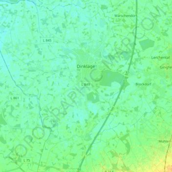
Name: Dinklage topographic map, elevation, terrain.
Location: Dinklage, Landkreis Vechta, Niedersachsen, 49413, Deutschland (52.59813 8.01833 52.70374 8.19141)
Average elevation: 29 m
Minimum elevation: 23 m
Maximum elevation: 45 m
Make a donation
Gear up for your next adventure:
As an Amazon Associate, this site earns from qualifying purchases at no extra cost to you.
Other topographic maps
Click on a map to view its topography, its elevation and its terrain.
Make a donation
Gear up for your next adventure:
As an Amazon Associate, this site earns from qualifying purchases at no extra cost to you.
Make a donation
Gear up for your next adventure:
As an Amazon Associate, this site earns from qualifying purchases at no extra cost to you.
Severinghausen
Deutschland > Niedersachsen > Landkreis Vechta > Neuenkirchen-Vörden
Average elevation: 59 m
Haverbeck
Deutschland > Niedersachsen > Landkreis Vechta > Damme > Langenteilen
Average elevation: 51 m
Rüschendorf
Deutschland > Niedersachsen > Landkreis Vechta > Damme > Rüschendorf
Average elevation: 50 m
Make a donation
Gear up for your next adventure:
As an Amazon Associate, this site earns from qualifying purchases at no extra cost to you.
Langenteilen
Deutschland > Niedersachsen > Landkreis Vechta > Damme > Langenteilen
Average elevation: 47 m
Nellinghof
Deutschland > Niedersachsen > Landkreis Vechta > Neuenkirchen-Vörden
Average elevation: 51 m
Make a donation
Gear up for your next adventure:
As an Amazon Associate, this site earns from qualifying purchases at no extra cost to you.