Geolocate

Munting Pulo topographic map

Click on the map to display elevation.

👉 Easily get elevation data in JSON, GeoTIFF and KML formats using Elevation API
Thank you for supporting this site ❤️
Make a donation

About this map

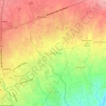
Name: Munting Pulo topographic map, elevation, terrain.

Location: Munting Pulo, Lipa, Batangas, Calabarzon, 4127, Philippines (13.93231 121.16587 13.97231 121.20587)

Average elevation: 312 m

Minimum elevation: 240 m

Maximum elevation: 359 m

Other topographic maps

Click on a map to view its topography, its elevation and its terrain.

Lipa City Community Park

Philippines > Batangas > Lipa

Average elevation: 311 m

Malepunyo Mountain Range

Philippines > Batangas > Lipa

Average elevation: 295 m

Pangao

Philippines > Batangas > Lipa

Average elevation: 324 m

Pinagkawitan

Philippines > Batangas > Lipa

Average elevation: 223 m

Sabang

Philippines > Batangas > Lipa

Average elevation: 324 m

Tambo

Philippines > Batangas > Lipa

Average elevation: 353 m

6

Philippines > Batangas > Lipa

Average elevation: 313 m

Lumbang

Philippines > Batangas > Lipa

Average elevation: 347 m

Halang

Philippines > Batangas > Lipa > Halang

Average elevation: 171 m

Sabang

Philippines > Batangas > Lipa

Average elevation: 324 m

Pangao

Philippines > Batangas > Lipa

Average elevation: 324 m

Gear up for your next adventure:

🎒Hiking Daypack - Lightweight and durable backpacks for day trips and excursions
Lightweight Backpacking Tent - Compact tent for efficient hiking trips
🧴Bear Spray Holster - Quick-access carry for essential Canadian wilderness safety
🌡️Emergency Mylar Blankets - Compact thermal protection for unexpected nights outdoors
👟Trail Running Shoes - Agile footwear for fast-paced topographic exploration

As an Amazon Associate, this site earns from qualifying purchases at no extra cost to you.