Geolocate

Falcon Heights topographic map

Click on the map to display elevation.

About this map

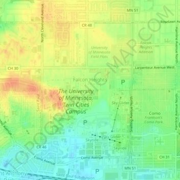
Name: Falcon Heights topographic map, elevation, terrain.

Location: Falcon Heights, Ramsey County, Minnesota, United States (44.97722 -93.19738 44.99904 -93.15656)

Average elevation: 291 m

Minimum elevation: 271 m

Maximum elevation: 310 m

Other topographic maps

Click on a map to view its topography, its elevation and its terrain.

Gladstone

United States > Minnesota > Ramsey County > Maplewood

Average elevation: 285 m

Midvale

United States > Minnesota > Ramsey County > Maplewood

Average elevation: 305 m

Como Lake

United States > Minnesota > Ramsey County > Saint Paul

Average elevation: 280 m

Gear up for your next adventure:

🧥Waterproof Hiking Jacket - Protect yourself from rain and wind while hiking
🧢Outdoor Visor - Breathable visor for sunny hikes
🥾Hiking Boots - Sturdy boots providing ankle support and traction on rugged trails
🧦Thermal Socks - Warm socks for winter hiking or camping
🧭GPS Tracker - Track your location in remote areas safely

As an Amazon Associate, this site earns from qualifying purchases at no extra cost to you.