
Make a donation
Gear up for your next adventure:
As an Amazon Associate, this site earns from qualifying purchases at no extra cost to you.
Distrito El Nihuil topographic map
Click on the map to display elevation.
Make a donation
Gear up for your next adventure:
As an Amazon Associate, this site earns from qualifying purchases at no extra cost to you.
About this map
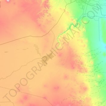
Name: Distrito El Nihuil topographic map, elevation, terrain.
Average elevation: 1,227 m
Minimum elevation: 559 m
Maximum elevation: 2,329 m
Make a donation
Gear up for your next adventure:
As an Amazon Associate, this site earns from qualifying purchases at no extra cost to you.
Other topographic maps
Click on a map to view its topography, its elevation and its terrain.
Cerro El Plata
Argentina > Mendoza > Distrito La Carrera
Cerro El Plata is the highest peak of the Cordón del Plata which is a subrange of the Andes. The mountain is located 65 kilometres (40 miles) southeast of Aconcagua and 60 kilometres (37 miles) west of the provincial capital, the city of Mendoza. Precipitation runoff from the mountains drains into the Mendoza…
Average elevation: 5,374 m
Andes
Argentina > Mendoza > Distrito Las Cuevas
The Andes Mountains are the highest mountain range outside Asia. The highest mountain outside Asia, Argentina's Mount Aconcagua, rises to an elevation of about 6,961 m (22,838 ft) above sea level. The peak of Chimborazo in the Ecuadorian Andes is farther from the Earth's center than any other location on the…
Average elevation: 6,208 m
Make a donation
Gear up for your next adventure:
As an Amazon Associate, this site earns from qualifying purchases at no extra cost to you.
Luján de Cuyo
Argentina > Mendoza > Departamento Luján de Cuyo > Luján de Cuyo
Average elevation: 951 m