
Make a donation
Gear up for your next adventure:
As an Amazon Associate, this site earns from qualifying purchases at no extra cost to you.
Cerro El Plata topographic map
Click on the map to display elevation.
Make a donation
Gear up for your next adventure:
As an Amazon Associate, this site earns from qualifying purchases at no extra cost to you.
Cerro El Plata
Cerro El Plata is the highest peak of the Cordón del Plata which is a subrange of the Andes. The mountain is located 65 kilometres (40 miles) southeast of Aconcagua and 60 kilometres (37 miles) west of the provincial capital, the city of Mendoza. Precipitation runoff from the mountains drains into the Mendoza River watershed. Topographic relief is significant as the west slope rises 2,170 meters (7,120 feet) in four kilometers (2.5 miles). The Spanish toponym "Cerro El Plata" translates to Silver Peak. The first ascent of the summit was made by Hans Stepanek on January 21, 1925.
Make a donation
Gear up for your next adventure:
As an Amazon Associate, this site earns from qualifying purchases at no extra cost to you.
About this map
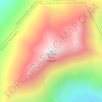
Name: Cerro El Plata topographic map, elevation, terrain.
Average elevation: 5,374 m
Minimum elevation: 4,622 m
Maximum elevation: 5,950 m
Make a donation
Gear up for your next adventure:
As an Amazon Associate, this site earns from qualifying purchases at no extra cost to you.