Geolocate

Bortala topographic map

Click on the map to display elevation.

About this map

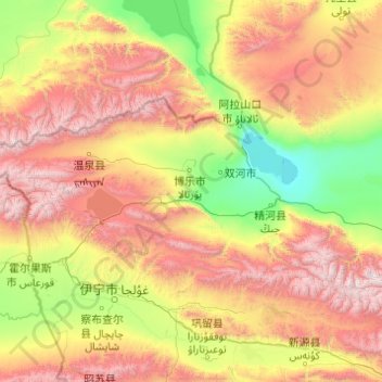
Name: Bortala topographic map, elevation, terrain.

Location: Bortala, Xinjiang, 833404, China (44.00554 79.88199 45.38609 83.79581)

Average elevation: 1,445 m

Minimum elevation: 193 m

Maximum elevation: 4,653 m

Other topographic maps

Click on a map to view its topography, its elevation and its terrain.

Tazhong

China > Xinjiang > Qarqan County > Tazhong Town

Average elevation: 1,116 m

Kaba

China > Xinjiang > Habahe County > 阿克齐镇

Average elevation: 557 m

Yiwu County

China > Xinjiang > Hami

Average elevation: 1,215 m

Korla

China > Xinjiang > Korla City

Average elevation: 1,034 m

Awat

China > Xinjiang > Awat County

Average elevation: 1,046 m

Gear up for your next adventure:

🧣Evaporative Cooling Towel - Beat the heat during intense summer climbs
💡LED Headlamp - Hands-free illumination for night hiking and camping
🎒Hiking Daypack - Lightweight and durable backpacks for day trips and excursions
💡LED Camping Lantern - Illuminate your campsite with long-lasting lanterns
🔥Emergency Fire Starter - Reliable ignition source for all weather conditions

As an Amazon Associate, this site earns from qualifying purchases at no extra cost to you.